#Phivolcs Update
Explore tagged Tumblr posts
Visit Tumblr Blog
Explore Tumblr blogs with no restrictions, modern design and the best experience.
Last Seen Tumblr Blogs


Fun Fact
Mobile Tumblr US users spend an average of 4.04 minutes per session on the app.
Text
Quezon Province Rocked by Magnitude 5.1 Quake
Quezon Province was hit with a magnitude 5.1 earthquake past lunch time today according to the Philippine Institute of Volcanology and Seismology (Phivolcs). The earthquake which was felt at 12:17 p.m. struck some 25 kilometers northwest of General Nakar, Quezon Province. It was deemed tectonic in origin by Phivolcs and had a depth of focus of 11 kilometers. The areas below reported the…
#earthquake monitor#earthquake philippines#earthquakePH#LindolPH#Luzon quake#news philippines#Phivolcs#Phivolcs Update
0 notes
Text
Clicks Towards Awareness 。゚☁︎。⋆。 ゚☾ ゚。⋆

How social media is keeping us updated and safe in a world with unpredictable nature.
Imagine this...

You're a child in the days where every information is only posted on printed materials, radios, and televisions. Suddenly, while playing outside, your mother screams!
"Hala, may bagyo! Hindi tayo nakapaghanda!"
Your household is out of food, candles, and with no first aid kit! You are all doomed and unprepared. No one expected that this would come.
Communication was definitely tough. During the onset of the typhoon, it was hard getting updates as signals for the television and radio were not available. Your family does not know when this disaster will end!
Some people didn't even know that there would be a typhoon until it rained hard and the winds became stronger. Since most only relied on television, radio, and printed materials, it was never guaranteed that the information would reach everyone.
Now faster forward to the current timeline...

Through the widespread use of technology, communication became easier with social media platforms. It became a medium that quickly spread information. Whatever a person posts, it can easily reach thousands or even millions of people!
Official agencies for disasters also now use social media platforms. They often update day to day reports on what will happen to the following days. Thus, everyone has a heads up days before the calamity.
HELPING FAMILIES ─── ⋆⋅☆⋅⋆ ──
Social media acts like an early warning system. All updates regarding disasters are posted online and easily reaches millions of people. This helps families to prepare early, evacuate early, and keep themselves safe from disasters.
HELPING SOCIAL WORKERS ─── ⋆⋅☆⋅⋆ ──
Social workers are the people for the people. In order to address the challenges faced by society, then they must know what are the problems needed to be solved. This is where social media comes in. It tells them everything they need to know in order to prepare in helping the people. They might need to prepare relief goods, rescue materials, or prepare themselves to assist people.
HELPING THE GOVERNMENT ─── ⋆⋅☆⋅⋆ ──
Social media is not just a platform for entertainment, but also a platform for awareness. There are multiple agencies online in various social media platforms. For example are PAGASA, NDRRMC, PHIVOLCS, and many more! Information dissemination from these agencies are much easier now. All their reports and observations are often posted online, which keeps people aware of their surroundings. It benefits them and the people by improving the communication between them.
#DisasterAwareness#DisasterPrepareness#Communication#InformationDIssemination#SocialMedia#Activity10.3#Spotify
1 note
·
View note
Text
Kanlaon Volcano Eruption Safety Measures: Protecting Lives During Volcanic Activity
During a volcanic eruption, it is crucial to prioritize safety and follow the guidelines provided by local authorities and volcanic monitoring agencies like the Philippine Institute of Volcanology and Seismology (PHIVOLCS). Here are some general safety measures to consider during a volcanic eruption: 1. Stay Informed: Keep yourself updated with the latest information and alerts issued by official…

View On WordPress
0 notes
Text
Social media towards information dissemination in times of calamity
In times of calamity, communication between different groups of people is crucial to disseminate information about proper procedures and updates with regards to the disaster. Since the social media starts to be integrated to our daily lives, not only does it provides entertainment, it includes access to effective and efficient communication as well.
Some of the ways social media has helped include but not limited to:
Rapid Communication
With the current applications and instruments available for everyone to use, communication between two or more groups of people have become highly effective and efficient. And in times of calamity, social media allows quick spread of information which can inform wide scope of people about updates, procedures, and can alert a large population. Although past mediums of information dissemination such as tv, radio, and print can reach a much wider population, the requirements to spread information (electricity, face-to-face interaction, etc.) may not be available in times of disaster.
Access to Real-time News
In addition to rapid communication, social media also allows immediate connection to one or more individuals. This is crucial for sudden changes to the calamity and the environment. Government agencies such as but not limited to PAGASA, PHIVOLCS, and NDRRMC. Since these agencies have immediate knowledge to the calamity, the very next thing they have to do is to disseminate the information in which social media has its use.
Advantage over Traditional Medias
Although traditional medias hold it's significance when it comes to information dissemination, social media has more advantages when it comes to the same purpose. Social media offers instant update which allows people to be alert at all times. Unlike traditional media which can only disseminate information later than the latest update, which is undoubtedly a huge drawback.
1 note
·
View note
Text
Hoyy gags! Medj katakot ah, literal na pinaikutan ng lindol BUONG Pilipinas in just span of hours.
Check PHIVOLCS updates.
1 note
·
View note
Text
Announcement:
Ok so, right now, I'm gonna apologize for not uploading as frequently as I did when I started this blog.
The reason is because, there's a possible volcanic eruption where I live. It's very near our place so my family's been stressing about it. We're about 61 Kilometers away from it but the ash fall already reached us a few days ago. The ash is made up or Carbon and Silica which is terribly dangerous. Not to mention how asthmatic my dad and I are😅 we're not sure if it's going to erupt, but we're already on Alert Level 4 and PHIVOLCS is already warning us that the volcano can erupt anytime now. If you research the Taal Volcano, the crater is in the middle of a lake, but here's the thing, the lake and the surrounding area IS the volcano. The one in the middle is just a visible part of it, along with the other 40+ craters . So yeah, it's huge.
If you search on Google, the Taal Volcano is on the way to erupting in the Philippines, but we hope that it doesn't. So if i don't get the requests done immediately, we're probably in the middle of evacuating or we don't have immediate access to WiFi.
Again, I'm sorry if I don't upload as much right now, but I will make up for it in the future.
Please, keep those requests coming because writing takes my mind off of the anxiety and I really take comfort in seeing people's support for my writing. It keeps me motivated and less stressed about this situation😅
P.S I'm sorry to tag non related things to this post, but I want my followers to see this and be aware of the situation in places near the Taal volcano in the Philippines.
Edit: so, apparently, the possibility of eruption is higher than I thought. In some places, the ground is breaking and cracking. Houses are getting destroyed and split in half because of this.
It means that there is movement in the magma, and because of the 40+ craters it has, we don't know where the magma might come out, or even if the whole lake will explode. If you research, the volcano was once so huge, that when it exploded, it destroyed the whole cone shape of it and made a lake. While the rocks and ashes made a semi-even ground around it, but it is still very much active with magma underneath all of those buildings and structures built over it.
The Taal Volcano is very unpredictable. There's even a chance of a horizontal explosion. There's a chance of all the craters erupting or the whole lake or just that one crater. The movement of the magma is so unpredictable guys.
I'll continue to update if anything happens if I have internet. I'm scared y'all.
Tag List:
@spideylovin @used-avocado @marvel-is-marvellous @annoylinglyaries @autobotgirl15-blog @shootingstarsaretearsofheaven
#tom holland x reader#tom holland and you#tom holland au#tom holland#tom holland soulmate au#tom holland x reader angst#peter benjamin parker#peter parker x stark!reader#peter parker x sister!reader#peter parker x reader#peter parker#harry holland x you#harry holland x reader#harry holland x y/n#harry holland#harrison osterfield#sam holland imagine#sam holland x reader#sam holland#paddy holland#harrison osterfield imagine#harrison osterfield x reader#tony stark x teen!reader#tony stark imagine#tony stark x reader#tony stark#robert downey junior#robert downey jr#ned leeds#spider man: far from home
63 notes
·
View notes
Text
kung magbabasa na rin lang kayo ng articles/updates about #TaalEruption siguraduhin niyo na credible yung sources niyo like PHIVOLCS
6 notes
·
View notes
Text
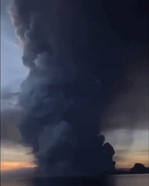
The world's smallest active volcano, Mt. Taal, just had a phreatic eruption
Sunday at 11 am, Mt. Taal expelled ash into the atmosphere due to a phreatic eruption. That's when magma hits water; understandable since Taal Volcano is surrounded by the Taal Lake. It's...hasn't been a fun day.

3 barangays (towns) have already been evacuated from the lakeside. The ash cloud now covers most of South and Central Luzon:

This is the view from a passenger in an airplane:

Ash is everywhere, and the sporadic rains aren't helping:

This photo was taken after a light rain, and the ashfall has worsened since then. As of posting this, it's nighttime, so I can't get a good picture of the ash, but for those interested, here are some links to local news:
Most provinces are ordering class suspensions on grounds of ash covering vehicles on the move, and the air smells like sulfur and wet clay. The ash is everywhere. Strays are being taken inside homes, there has been attempts to spray off the growing layer of ash with water, and most air-sensitive folks are having trouble breathing. And this is just the beginning.
#philippines#volcano#volcanic eruption#eruption#taal#taal volcano#phreatic eruption#news#ashfall#ash#volcanic ash
5 notes
·
View notes
Text
When the facts get in the way of your right-on agenda
TLDR: Taal Volcano (located in the Philippines) is active right now and could have a massive eruption at any moment. ~560,000 people are in immediate danger and millions more could be affected by it.
(this is barely being reported on by western news btw. why talk about natural disasters when we could talk about british royal family drama)
gruftiweb

“Barely reported.”
The Independent website (UK newspaper): today
Taal volcano news – live: Cracks spotted in earth and more quakes spark fear of huge explosion as police extend blockade
Daily Express 2 days ago
Taal volcano eruption: NASA satellite scans reveal TOXIC sulphur clouds spewing from TaalTAAL volcano in the Philippines is spewing thick clouds of toxic sulphur dioxide (SO2) into the air, NASA satellite scans reveal, amid growing concerns the eruption will deteriorate in the coming days.By SEBASTIAN KETTLEY
Stark images show horses killed by Taal Volcano | Daily Mail ...
1 day ago - Buried beneath the ash: Stark images show horses killed by Taal Volcano lying beneath thick layers of ash as operation begins to rescue other ...
The risk of a potentially catastrophic eruption at ... - Daily Mail
5 hours ago - The risk of a potentially catastrophic eruption at the Philippines' Taal volcano is still high, officials warn - as President Duterte says: 'I'll pee on ...
www.telegraph.co.uk › News 'most dangerous' volcano for months - The Telegraph
2 days ago - The Philippine Institute of Volcanology and Seismology (Phivolcs) is maintaining the alert level for the Taal volcano at 4, meaning a hazardous ...
www.standard.co.uk › News › World Taal volcano eruption update LIVE: Thousands flee danger ...
32 mins ago - Fears of a larger Taal volcano eruption continue to mount as ... supply of face masks dropped and prices increased to as much as five times the
www.nytimes.com › briefing › iran-burisma-taal-volcano-australian-open Iran, Burisma, Taal Volcano - The New York Times2 days ago - Brooding Volcanic Monster Menaces the Philippines ... .
www.latimes.com › world-nation › story › philippine-volcano-spews-l... Increasingly active Philippine volcano raises fears of new ...
2 days ago - Philippine schools close and flights are canceled as a volcano near Manila spews ... The continuous restiveness of the Taal volcano and several new fissures ... a mile into the sky, and the massive column of ash and volcanic debris at times lit up with streaks of lightning. ...
(CNN)Images from the erupting Taal volcano in the Philippines show a desolate landscape of destroyed houses and snapped trees covered in a thick layer of heavy ash. Half-buried bodies of horses and cows that could not escape the island lay in black sludge or floating in the surrounding lake.
Other natural disasters recently all over the news: Australian bushfires, Brazilian bushfires, floods in Jakarta, New Zealand volcano.
#sometimes the Royal Family provides us with much needed relief from the real bad news in the world today, particularly natural disasters, but also Brexit, Trump, Iran, Putin.......
#I’m sure the Western media will be all over it when it happens. For at least a couple of days. Before the next natural disaster/war/Trump/Brexit/financial scandal or collapse/cute picture of cats wearing hats.
#There’s only so much bad news people can take
# Broadcast news is only news if there’s a TV camera to take the pictures
4 notes
·
View notes
Photo
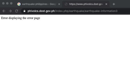
There was an earthquake at 3:17am and I tried to access the Phivolcs page. Maybe they were still trying to update the page. That error pag is both redundant and ironic. It was an intensity 5.1 earthquake in Mindoro.
1 note
·
View note
Text
grabe yung earthquake update ng phivolcs sa fb?? Like sunod sunod yung lindol around batangas and cavite 😳
3 notes
·
View notes
Text
Magnitude 5.3 Quake Hits Agusan del Sur
A magnitude 5.3 quake rattled the province of Agusan del Sur yesterday at 6:26 p.m. The Philippine Institute of Volcanology and Seismology (Phivolcs) determined its epicenter to be some 10 kilometers northeast of Talacogon, Agusan Del Sur. It has a depth of focus of kilometers and is tectonic in origin. The following intensities were reported: Intensity IV – City of Bislig and Hinatuan,…
#Agusan del Sur#earthquake monitor#earthquake philippines#earthquakePH#LindolPH#mindanao earthquake#news philippines#Phivolcs#Phivolcs Update
0 notes
Text


A BEAUTIFUL DISASTER
Taal Volcano is one of the most active volcanoes in the Philippines. Located in the province of Batangas which is not far from the capital city Manila.
The beauty of Taal Volcano captured the heart of the people not only from the Philippines but also around the world. Taal is also known as "a lake within a lake" from which is the volcano is within a lake and the crater itself is also a lake. For the past decades, Taal was silent from its last eruption which was in 1977. Just like Taal Volcano everyone that surrounds it is silent and making Taal a tourist spot from its unique form and beautiful scenery. Everything is going well until the silence broke.
Last January 12, 2020, the sleeping volcano awakened without a warning. The beautiful scenery turned into a disaster. From the day of the awakening, Taal Volcano changes the place from where smiles and laughter are formed into sorrow and sadness. Many of the residents lost their way of living, belongings and hope for a peaceful year at once. Never would have imagined that a picture-perfect scenery will change the way people think and live their lives after so many decades of silence from Taal Volcano.
As of now The Philippine Institute of Volcanology also known as PHIVOLCS is still on watch for Taal Volcano's state.
By: NINA ARTAJO
Taal UPDATE: https://www.phivolcs.dost.gov.ph/index.php/taal-volcano-bulletin-menu/9692-taal-volcano-bulletin-25-january-2020-8-00-a-m
1 note
·
View note
Text
Kanlaon Volcano Eruption Safety Measures: Protecting Lives During Volcanic Activity
During a volcanic eruption, it is crucial to prioritize safety and follow the guidelines provided by local authorities and volcanic monitoring agencies like the Philippine Institute of Volcanology and Seismology (PHIVOLCS). Here are some general safety measures to consider during a volcanic eruption: 1. Stay Informed: Keep yourself updated with the latest information and alerts issued by official…

View On WordPress
0 notes
Text
MODULE 3: DRRM KWENTUHAN
ADDRESS: Brgy. San Dionisio, Sucat, Parañaque City
I live in Parañaque City for 19 years now and I am grateful to explore our barangay. Kagawad Rodolfo Miranda Santos is the barangay official.


HAZARD IDENTIFICATION
The natural calamities which strikes the community are the earthquakes, fires, epidermic and typhoons. There have been times when typhoons pass by the community cause floods in the small areas and if there is an earthquake, minor aftershocks were felt. Other hazards that exists around the community is having a Improper Waste Disposal which also results to flood.
In the community, the risk that also experience is thief and commonly reasons why people come here.
The News especially PAGASA and PHIVOLCS and also the media are the source when it comes to typhoon and earthquakes. The barangay is updated all the happenings in news 24/7 for the safety of the people.

VULNERABILITY, ELEMENTS AND PEOPLE AT RISK MANAGEMENT
The most affected area around the barangay is the palanyag road wherein floods is very high and many disposed materials are in there. Many informal settlers also lived there which cause over popularity.

Mostly likely the people who will be affected are the ones who is living in a small areas in parañaque and especially the informal settlers. Also, the places who is also prone in floods like the Gatchalian Subdivision, Olivarez Plaza and Kabihasnan.
When the typhoon strikes in the community, the people would have experience low productivity in services. In terms of economics, the stores will be close,which the customers can’t accommodate it when a natural disaster strikes.
The most safe area during typhoon is your home. But when your area is affected in flash floods, you may go in the basketball court near the barangay. When it comes to earthquake, the safest place is an open area but before going there, make sure to perform duck, cover, and hold to the area where you are before going out.
The problems that the community experience sometimes is the lack of food and resources which the government cannot provide in a certain period of time and also the manpower. But the staff is always active and prepared any cases in the community.
CAPACITY AND DISASTER MANAGEMENT
The barangay have an equipment such as a disaster kit, first aid, rescue boat in case of emergency. There are also inspections in the community to inspect and assist those in need such as the response team to ensure the safety of the people. The barangay also inform via public address and social media to announce the upcoming disaster. Lastly, the barangay provides relief goods such as food and clothing to those affected.


The one who is in charge of preparing and dealing with the natural disasters is the Mayor and the Barangay Disaster Risk Reduction Commitee (BDRRC).
COMMUNITY WALK
Hazardous Places


The pictures above shows the hazard which commonly happens in the community. The unorganized waste disposal, floods happening and the traffic jam causes hazard by creating massive destruction that affect the barangay.
SAFEST PLACE


The safest place for people to stay is the church which they allow to evacuate the people during the state of calamity. Also, the open area beside the barangay hall is a safest place because they provide equipment and relief goods to the community.
BEST PRACTICES


The best practices in order for us to have a better community is keeping the peace in the society. With peace, unity will occur and everybody can rely with one another and help each other out in times of trouble. Also, practicing seriously the drills provided by the safety officers can prepare us in all forms of disasters that will come.
REFLECTION
In my interview with the barangay head, I notice that many challenges in our life and with the community will come. We cannot stop the hazards around us but we can minimize and be prepared on what we will do during calamities. The barangay is always prepared and ready in action. Without them, we would not unite and many problems will not be solve without them. As I explore the community, changing our perspective and taking care of the community is not too late. Change should start with us so that we can have a peace and clean community.
1 note
·
View note
Text
Barangay DRRM Kwentuhan by Francis Pio of NSTP L-AB-9
Barangay 471 Zone 46 District IV
Hazard Identification
After consulting with Eugene Cruz, the Executive Officer of Brgy. 471, I have come to know that the frequent hazards and disasters that occur in the barangay are floods, earthquakes, fires, and super typhoons. There are also cases of minor vehicular accidents and snatching in the area.
The barangay is equipped with flood indicators to monitor the water level whenever an imminent flood or typhoon is to hit and affect the barangay. They would also coordinate with fellow barangays to know the situation of each other to prepare for an imminent flood or disaster. Mr. Cruz also said that they tune in for updates from the local news station to know about any impending natural or man-made disasters.
Based on the data of the Philippine Institute of Volcanology and Seismology (PhiVolcs), the “Big One” or the devastating earthquake due to the movement of the West Valley Fault may occur anytime during this lifetime. Also, the barangay gave reports about the past typhoons that greatly affected their GDP such as Typhoon Ondoy, Pedring, Quiel, and Sendong.


Vulnerability, Elements, and People at Risk Assessment
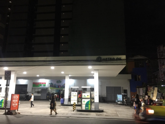
According to Mr. Cruz, the most vulnerable parts of the barangay whenever an earthquake strikes are the areas near tall buildings. He said that it is very dangerous to stay near them whenever it occurs. He also added that the barangay is geographically near a gasoline station. And its proximity is also a threat because it may explode when a disaster arises. Mr. Cruz also told me that the whole barangay is prone to flood whereas, Juaning and Navarra street and establishments are prone to fire and earthquakes.
The streets are also unsafe places. Not only is it prone to floods but it is also the host for various vehicular and snatching incidents. Old houses are also an imminent threat to society. It is because of its old and decomposing wood that makes it highly vulnerable to fire.
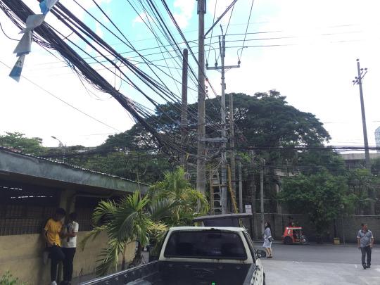
Based on my observation, the electrical wires are also a dangerous thing when disaster arise. Bundles of wires crawl around the barangay and it is prone to breaking and may cause a fire when it does.
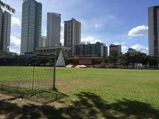
Mr. Cruz said those old people, poor, persons with disabilities and children are most vulnerable when these disasters arise. It is because of this that the Barangay 471 made evacuation centers for its constituents. They have made the 2nd and 3rd floor of the barangay hall as the primary evacuation center and coordinated with Raha Volunteer to make their fire station and the UST Football Field as evacuation centers.
The Barangay is considered as a semi-commercial area with its residents’ income-generating capabilities sprout from food stalls, commercial establishments, transport services, and sari-sari store. If a flood or a fire occurs in these places, the residents may lose their revenues as it is their primary source of income.
Capacity and Disaster Management Assessment
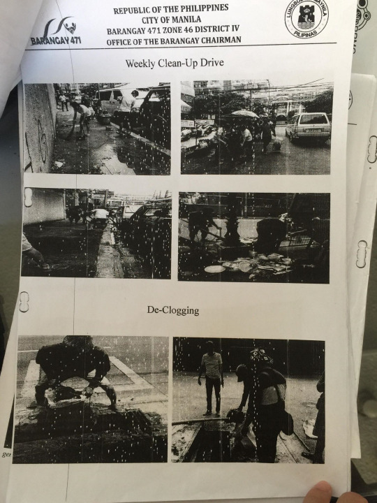
The Barangay has a Barangay Risk Reduction Management Plan that Mr. Cruz was kind enough to show me. Base on the plan, the barangay had various activities, pieces of equipment, and procedures to follow and use whenever a hazard or disaster strikes.
In anticipation of floods and typhoons, the barangay conducts a weekly declogging and clean-up drive to remove garbages from sewers and allow water to freely pass and avoid clogs that may result to flood. They also have a megaphone and a two-way radio in-store to help during these disasters.

On the other hand, in anticipation of earthquakes and fires, Mr. Cruz told me that the Raha Fire Volunteer had been a dependent organization in case of any incidents. It is because of their capable fire trucks, amphibious vehicles, and ambulances that they can perform well. However, the barangay is not incapable of protecting themselves.
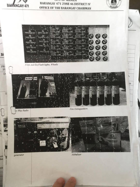
Mr. Cruz told me that they have enough tanods to help in any emergencies and their pieces of equipment such as fire extinguishers, first aid kits, BP apparatus, two-way radios, flashlights, whistles, generator, and the nebulizer is always ready to be used in case of any emergency.
It is also in the direct supervision of Hon. PB Osmundo J. Perez to be responsible for the Barangay Disaster Coordinating Council (BDCC), Alfonso Adalia for the Fire Brigade Team, Kagawad Adelaida Rabe for the Medical Service Team, Lito Espera and Evelyn Rodriguez for the Damage Control Team and Security Service Team, respectively.

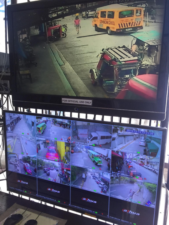
I have also observed that the Barangay had installed a CCTV system that stretches along the street of Navarra and other streets as Mr. Cruz said it was a busy street that needs a lot of surveillance. It is also used to track water levels, vehicular or snatching incidents.
Community Walk
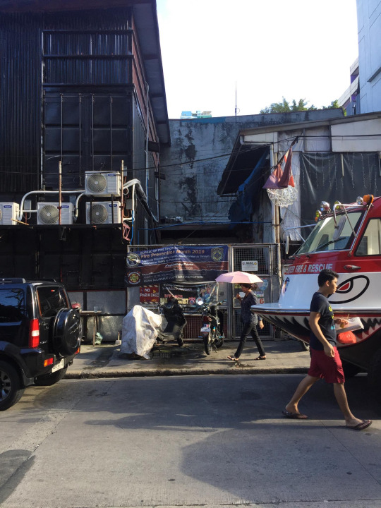
As I have done my walk to observe the barangay, I have seen that it really is a place of busy students. And the traffic along with it is dangerous to their safety. I have also seen the danger of numerous bundles of hanging electrical wires that are only waiting to be a disaster on its own.
Also, I have observed that there is little to no street barriers along the streets of UST and Barangay 471. Danger may strike anytime and unknowing pedestrians may be a victim of car accidents.
Tall buildings and old houses are also a sight for the eyes. These dangerous infrastructures are needed to be properly maintained.
Hazardous Places
As I see it, the most hazardous places are near tall buildings and establishments with a lot of bundled electrical wires. Also, there are not enough precautions on the street such as street barriers to protects pedestrians from any vehicular accidents.
Safe Places
The UST football field is one of the safest places near the barangay and it can accommodate hundreds of people whenever a disaster strikes.
Best Practices
I believe that what the barangay does for the prevention of flood and for the cleanliness of the community is one of the best practices of it. The Clean-up drive and declogging practices can go a long way. It will enhance the capacity of the barangay to be more prepared and save lives and businesses in the first place.
Reflection, Synthesis, and Analysis
After conducting the DRRM Barangay Kwentuhan, I am now more aware of the plans that the barangay has in-store for the protection and preservation of life and the harmony of its constituents. It is quite assuring to know that there are these initiatives solely to benefit us.
However, I just wish that more people would be more willing to actively and effectively implement these practices. Also, I wish that there were more civic awareness and importance in the minds of the people. So that these actions can be improved and effectively implemented.
With the knowledge of the disasters and hazards in my community, I have now the duty and responsibility to look out for my self and others. I have to effectively communicate my knowledge for the betterment of the community. Also, I can help with the preparation and dissemination of the idea as to where to go in times of a disaster or who to call.
The Philippines is an archipelago and we are situated near the Pacific ocean. Typhoons will inevitably devastate the country and we can do nothing to stop it. Fortunately, we can be prepared for it. By being ready and competent for disasters at the smallest level of the barangay, we can be ready for any disaster as a nation. We need to reinforce our preparedness down to its core, the people of the barangay so that we can mitigate these disasters that affect our community.
We can do it by training our barangay officers and also its constituents and equipping them with the right tools to undergo such training. We should also come up with an efficient disaster preparedness plan so that we can follow a system whenever a disaster strike. This will not only include barangay officials but the coordination of the people is also a vital aspect for its success. Hence, I can say that this National Service and Training Program (NSTP), is not a mere subject for the school but is a subject for the survival and progress of the country.
1 note
·
View note